Agriculture Land Area Calculation – Formulas, Methods, and Tools Every Farmer Should Know

Agriculture Land Area Calculation
Formulas, Methods, and Tools Every Farmer Should Know
Complete guide to agricultural land measurement: learn formulas, GPS field measurement techniques, GIS land mapping, acre to hectare conversion, and digital tools for accurate farmland calculation.
Why Measuring Your Land Is the First Step to Farming Smarter
Before a single seed goes into the ground, before irrigation lines are laid, before fertilizer is ordered, and before any farm management decision is made — the land must be measured. Agriculture land area calculation is not a bureaucratic formality. Instead, it is one of the most practically important skills in all of farming. However, many farmers, especially those new to agriculture, approach this task without the right tools or knowledge. Consequently, they often face unexpected costs and planning challenges.
Whether you are managing a small farm in a rural community, overseeing thousands of acres of commercial cropland, planning an urban farming project, or simply trying to understand your agricultural land for insurance, financing, or leasing purposes — accurate farmland calculation is fundamental to everything that follows. Therefore, mastering this skill is essential for agricultural success. Moreover, it directly impacts your bottom line.
What Is Agriculture Land Area Calculation?
Agriculture land area calculation refers to the process of determining the size of a piece of farmland — expressed in standard units such as acres, hectares, or square meters. This measurement forms the basis for almost every other agricultural planning and management decision. Furthermore, it serves as the foundation for precision agriculture systems. Without accurate measurements, these advanced systems cannot function properly.
At its simplest, land measurement in agriculture answers the question: how big is this field? However, the implications of that answer reach far and wide. Specifically, it determines how much seed to purchase, how much fertilizer agriculture operations will require, how irrigation systems should be designed, what the expected crop yield might be, and how much the land is worth. Therefore, the agricultural land size calculator — whether a simple formula, a smartphone app, or a sophisticated GIS mapping system — is not just a mathematical tool. Instead, it is a planning instrument at the core of precision farming and smart agriculture. Thus, every farmer should become proficient in land measurement.
Why Land Measurement in Agriculture Matters
The importance of land measurement in agriculture cannot be overstated. Here is what accurate farmland calculation enables for modern farming operations. Moreover, these benefits extend across all farming scales and types.
📦 Input Planning & Cost Management
Every agricultural input — seed, water, fertilizer, pesticide, agricultural lime — is applied per unit of area. Without accurate crop field area calculation, farmers either over-apply inputs (wasting money and harming the environment) or under-apply them (reducing yields). Thus, accurate acreage estimation is directly tied to farm profitability. Consequently, measurement errors lead directly to financial losses.
💰 Agricultural Finance & Land Valuation
Agricultural land valuation for buying, selling, leasing, or mortgaging depends entirely on accurate area measurement. Institutions like the National Bank for Agriculture and Rural Development require verified land area data. Consequently, having certified measurement data is essential for securing agri finance. Therefore, accurate measurement opens doors to better financing options.
🎯 Precision Agriculture & Smart Farming
In precision agriculture, field area data is the foundation for everything. Precision farming maps, variable rate application, drone sprayer flight planning, and automated tractor routing all depend on accurate digital representations of field boundaries. Therefore, reliable agricultural GIS tools are critical for these systems. Furthermore, without accurate measurements, precision agriculture cannot deliver its promised benefits.
🏛️ Government Programs & Agricultural Grants
USDA grant programs, conservation agriculture initiatives, and FAO-supported projects all require accurate land area data for eligibility determination. For this reason, verified land area records are non-negotiable for program participation. Additionally, inaccurate measurements can lead to compliance issues and funding denial.
📈 Crop Yield Estimation & Farm Planning
Knowing the exact size of each field enables accurate crop yield estimation and farm management planning. Consequently, this supports both day-to-day decisions and long-term agribusiness management strategies. Ultimately, better measurements lead to better farm planning and higher profits.
Units of Land Measurement Used in Agriculture
Before calculating, it is important to understand the units used in agricultural area measurement around the world. Moreover, knowing these conversions is essential for international agribusiness. Therefore, we have detailed the most common units below.
Acre
The acre is the most commonly used land measurement unit in the United States, the United Kingdom, and many countries influenced by British agricultural systems. One acre equals 43,560 square feet or approximately 4,047 square meters. In US agriculture, monitored by the United States Department of Agriculture, acreage is the standard reference for field size. Therefore, knowing how many square feet are in an acre (43,560) is foundational for any agriculture land calculator. Furthermore, this knowledge is essential for USDA reporting.
Hectare
The hectare is the international standard unit for agricultural land measurement, widely used across Europe, Asia, Africa, and regions reported through FAOSTAT. One hectare equals 10,000 square meters or approximately 2.471 acres. To convert hectares to acres: multiply hectares by 2.471. To convert acres to hectares: multiply acres by 0.4047. Consequently, this hectare conversion is among the most commonly performed calculations in international agribusiness. Thus, understanding hectares is crucial for global trade.
Square Meter and Square Feet
For smaller plots — common in urban farming, urban gardening, greenhouse farming, or small scale farming — square meters and square feet are the practical units. Square feet to acre conversion (divide by 43,560) is a routine calculation for small farm operators. Thus, mastering these conversions is valuable for all farmers. Additionally, these units are often used in property listings and lease agreements.
Traditional Methods of Agricultural Land Area Calculation
Understanding where land measurement has come from helps appreciate how far modern tools have advanced. Furthermore, traditional methods remain useful for quick estimates and educational purposes. Nevertheless, they have largely been replaced by digital alternatives for commercial farming.
Chain and Tape Measurement
For centuries, land survey farming relied on physical measurement tools — chains, tapes, and rods — to measure field boundaries. A surveyor would walk the perimeter of a field, recording distances and angles to calculate area using geometric formulas. While labor-intensive and prone to human error, this method laid the groundwork for modern cadastral land survey systems. Therefore, understanding this method provides valuable context. However, few farmers use it today due to its inefficiency.
Geometric Formulas for Regular Fields
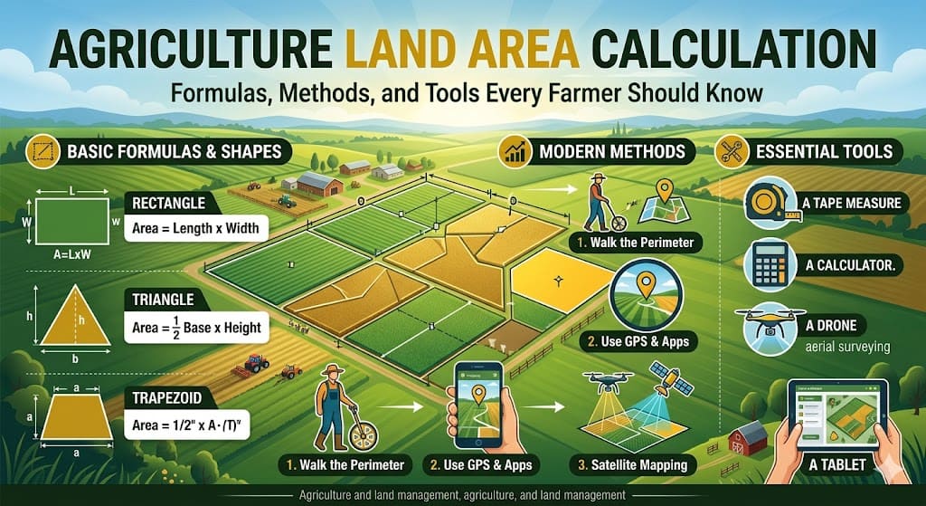
For rectangular or square fields, the agriculture land calculation formula is straightforward: Area = Length × Width. For a triangular field: Area = 0.5 × Base × Height. For irregular fields, the field was divided into smaller regular shapes, each calculated separately and then totaled. Consequently, these basic agriculture land calculation formulas remain useful today for quick estimates and for understanding the logic behind more complex digital tools. Thus, every farmer should know these basic formulas.
Modern Methods of Agricultural Area Measurement
The transformation from manual to digital land measurement has been one of the most impactful shifts in modern agriculture. Today, farmers have access to a range of powerful, accurate, and easy-to-use digital tools for agricultural land calculation. Consequently, measurement accuracy has improved dramatically while time and effort have decreased.
🛰️ GPS Field Measurement
GPS-based land measurement is now the most widely used method for accurate farmland area calculation. These tools use satellite signals to track field boundaries as the user walks or drives the perimeter. The device then automatically calculates the enclosed area. How does GPS calculate farm area? The device records GPS coordinates that form a polygon, then calculates the area using geometric algorithms. Modern consumer-grade GPS tools achieve accuracy within a few meters. Therefore, this method is both accessible and reliable.
🗺️ Agricultural GIS Tools & GIS Land Mapping
Geographic Information Systems represent the most sophisticated level of agricultural area measurement. Agriculture GIS mapping allows farmers to create detailed digital maps, overlay data layers such as soil type and elevation, perform precision land mapping, and connect field boundary data with precision farming maps. Therefore, GIS land mapping is used extensively in precision agriculture and climate smart agriculture planning. Furthermore, it enables sophisticated data analysis.
📱 Agriculture Land Calculator Apps
A new generation of agriculture land calculator apps has made accurate farmland area calculation accessible to every farmer with a smartphone. These apps allow users to walk boundaries and automatically calculate area, draw boundaries on satellite imagery, convert between units instantly, and share field data with advisors. Consequently, the best apps are now integrated with broader digital agriculture platforms. Thus, even small-scale farmers can access professional-grade measurement tools.
🚁 Drone Surveying for Farmland
Drone surveying has emerged as one of the most accurate and efficient methods for larger properties. Agricultural drones equipped with GPS and imaging sensors can fly programmed grids, generating highly accurate land plotting software outputs. Drone-based farm mapping delivers centimeter-level accuracy, complete aerial imagery, 3D terrain models, and integration with GIS land mapping software. However, this method requires higher initial investment. Nevertheless, it pays off quickly for large operations.
🛰️ Satellite Land Measurement
Satellite imagery has made satellite land measurement accessible at a global scale. Platforms like Google Earth allow farmers to measure field boundaries directly from satellite images. While less accurate than GPS for individual boundaries, it is highly practical for rapid estimation and regional farm area assessment. Therefore, it serves as an excellent preliminary measurement tool.
Agriculture Land Calculation Formulas: A Practical Reference
Here is a practical reference of the most commonly used agricultural land area calculation formulas. Moreover, these formulas form the basis of all digital measurement tools. Consequently, understanding them helps farmers verify digital measurements and perform quick manual calculations when needed.
📐 Rectangle or Square Field
Area = Length × Width
Most common for regular-shaped crop fields.
📐 Triangle Field
Area = 0.5 × Base × Height
Useful for corner portions of irregular farms.
📐 Trapezoid Field
Area = 0.5 × (Side A + Side B) × Height
Common in fields with one irregular boundary.
🔄 Acre to Hectare Conversion
Hectares = Acres × 0.4047
Essential for international agribusiness.
🔄 Hectare to Acre Conversion
Acres = Hectares × 2.471
Most commonly performed calculation globally.
📏 Square Meters to Acres
Acres = Square Meters ÷ 4047
Useful for smaller plot measurement.
How to Measure Farm Land Accurately: Step by Step
Understanding how to measure farm land accurately depends on which method is being used. Here is how the most common approaches work in practice. Furthermore, each method has its own advantages and ideal use cases.
Using a GPS App for Field Area Calculation
First, open the agriculture land area calculator app on your smartphone. Then, stand at a corner point of the field and mark your starting position. Next, walk slowly along the entire field boundary, keeping the GPS signal active. After that, return to the starting point and close the boundary. Finally, the app automatically calculates and displays the field area in your chosen unit. Consequently, you can save the measurement with a field name for future reference. This method works for fields of any shape — making it the most versatile approach. Therefore, it is highly recommended for most farmers.
Using Satellite Imagery in a GIS Tool
First, open the agricultural GIS tool or mapping application. Then, search for the farm location using an address or GPS coordinates. Next, use the polygon drawing tool to trace the field boundary on the satellite image. After that, the tool automatically calculates the enclosed area. Finally, export the data in your preferred format for use in farm planning. Thus, this method requires no physical walking of the field.
Traditional Tape Measurement for Small Fields
First, divide the field into regular geometric sections (rectangles, triangles). Then, measure the length and width of each section using a measuring tape. Next, apply the appropriate agriculture land calculation formula to each section. Finally, total all sections for the complete field area. Therefore, this method remains useful for small plots and educational purposes. However, it is not recommended for large or irregular fields.
Frequently Asked Questions About Agriculture Land Area Calculation
📐 Basic Calculation Methods
🔄 Unit Conversions: Acres, Hectares, and More
🛰️ GPS and Digital Measurement Tools
⭐ Why Land Measurement Matters
Conclusion: Measuring Land Is Measuring Potential
Every acre of agricultural land represents potential — the potential to produce food, generate income, support a family, contribute to a community, and participate in the global food system. However, potential without measurement is guesswork. Therefore, accurate agriculture land area calculation is how farmers convert potential into reality. Consequently, those who measure well consistently outperform those who do not.
The journey from walking a field with a chain and measuring tape to using GPS farm mapping, agricultural GIS tools, and drone surveying has been remarkable. What once took days of manual surveying can now
📚 Related Guides from Agri Opportunities
↗️ Drone Surveying for Farm Land ↗️ GIS Applications in Agriculture ↗️ Sustainable Agriculture Practices📚 External Resources & Further Reading
Add Agri Opportunities as a preferred source on Google to see latest blog listings first.