The Auxiliary Efficacy of Drones in Precision Agriculture – Reshaping How the World Farms

The Auxiliary Efficacy of Drones in Precision Agriculture
Reshaping How the World Farms
Discover how agricultural drones enable precision crop management, NDVI crop analysis, drone crop spraying, farm mapping technology, and sustainable farming practices across all farming systems.
A New Chapter in Agricultural History
For most of human history, farming was an act of intuition. Farmers walked their fields, touched the soil, watched the sky, and made decisions based on experience passed down through generations. That instinct still matters. However, today it is being powerfully supported by something new: agricultural drones.
The auxiliary efficacy of drones in precision agriculture is not just a technical phrase. Instead, it describes a fundamental shift in how farm management decisions are made. Drones do not replace the farmer. Rather, they extend what the farmer can see, know, and do. Consequently, they serve as auxiliary tools: supportive, precise, and increasingly indispensable across every type of farming system. This includes large-scale commercial farmland, small scale farming plots, and urban farming operations. Therefore, understanding this technology is essential for modern agriculture.
Understanding Precision Agriculture and the Drone’s Place In It
Precision agriculture — also called precision farming or precision ag — is a farming management approach that uses technology to observe, measure, and respond to variability in crops, soil, and environmental conditions. Rather than applying the same treatment across an entire field, precision farming allows farmers to treat specific zones differently based on actual data. Therefore, this approach improves efficiency and reduces waste. Moreover, it forms the foundation upon which drone technology delivers its greatest value.
At the heart of this system is the need for accurate, real-time field information. This is exactly where UAVs in agriculture — unmanned aerial vehicles commonly known as drones — play their most critical auxiliary role. Traditional aerial imaging using satellites or manned aircraft was expensive, infrequent, and often limited by cloud cover. Fortunately, agricultural drones changed that equation completely. They are affordable, deployable within minutes, and capable of capturing multispectral imaging, NDVI crop analysis data, and aerial field surveillance at a resolution that satellites cannot match. Consequently, this enables a level of precision crop management that was simply not achievable before drone technology became accessible to the broader agriculture industry.
What Does “Auxiliary Efficacy” Actually Mean?
The word “auxiliary” is key here. Drones in precision agriculture are not standalone systems. Instead, they work alongside existing farm machinery, digital farming platforms, smart agriculture systems, and human decision-making. Their efficacy — their actual measurable impact — comes from how well they integrate with and amplify everything else already happening on the farm. Thus, the value of drones depends on the broader system within which they operate.
This auxiliary efficacy of drones in precision agriculture manifests in several ways. First, they gather data that other tools cannot easily collect. Second, they execute tasks — like drone crop spraying — with a level of precision that conventional equipment struggles to achieve. Third, they feed information into agricultural data analytics platforms that then guide tractor operations, irrigation adjustments, and input applications. Finally, they reduce the time lag between identifying a field problem and acting on it. Therefore, drone efficacy in farming is not measured in isolation. Instead, it is measured by what the whole farm system achieves when drones are a part of it. Consequently, integrated approaches yield the best results.
How Agricultural Drones Work: The Core Technology
To appreciate what drones offer agriculture, it helps to understand the basic technologies involved. These technologies work together to create actionable farm intelligence.
Remote Sensing Agriculture
Remote sensing agriculture involves capturing data about the physical world without direct contact. Drones carry various types of sensors that detect light, heat, moisture, and plant health indicators. The most commonly used sensors in agricultural drone applications include RGB cameras for standard color imaging, multispectral cameras that capture wavelengths beyond visible light, thermal sensors that detect heat variation, and LiDAR sensors that create precise three-dimensional maps of terrain and crop canopy. Furthermore, each sensor type serves a unique purpose in farm management.
NDVI Crop Analysis
One of the most powerful outputs of drone imaging in farming is the Normalized Difference Vegetation Index — NDVI. This index uses multispectral imaging data to measure plant health across an entire field. Specifically, it produces color-coded maps that show exactly which zones are thriving and which are under stress. Consequently, NDVI crop analysis is now a standard tool in smart farming, used by agronomists, agriculture students, and commercial farmers alike. For this reason, NDVI has become an essential component of precision agriculture.
GPS-Guided Drones
Modern agricultural drones rely on GPS-guided navigation to fly precise, repeatable flight paths. This means the same field can be scanned under the same conditions week after week. Therefore, farmers can track crop development, detect changes, and monitor treatment effectiveness over time. GPS-guided drones also enable automated spraying systems to apply inputs only to targeted areas — a defining feature of variable rate application in precision farming technology. Ultimately, GPS guidance ensures consistency and accuracy across all drone operations.
Drone Applications for Crop Monitoring and Spraying
The range of agricultural drone applications is broad and still expanding. Here are the most impactful ways drones are currently being used across farming operations worldwide. Moreover, these applications continue to evolve as technology improves.
🌾 Aerial Crop Monitoring
This application allows farmers to survey hundreds of acres in a single flight. It identifies plant health issues, uneven germination, waterlogging, and crop damage. Consequently, real-time field monitoring that once took days now takes hours.
🚁 Drone Crop Spraying
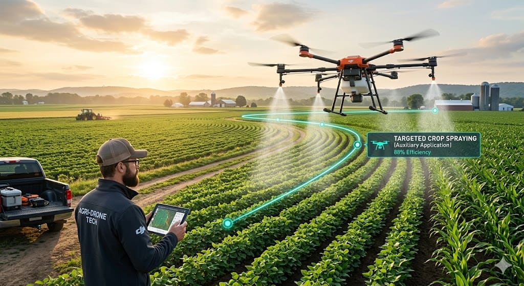
DJI Agras T40 and XAG P100 systems apply pesticides and fertilizers precisely. As a result, chemical use reduces by 30-50% compared to blanket spraying. Additionally, these systems operate in difficult terrain where conventional machinery cannot go.
🦠 Pest & Disease Detection
AI-powered analytics identify fungal infections and pest infestations early. Specifically, they detect issues before visible symptoms appear. Therefore, this capability dramatically reduces crop losses and unnecessary pesticide applications.
📈 Crop Yield Estimation
This technology generates accurate yield predictions based on plant density and health. Hence, it enables better harvest planning and marketing decisions. Furthermore, it supports agricultural finance and insurance assessments.
🗺️ Farm Mapping Technology
Drones create detailed digital models including elevation maps and soil variability zones. These maps form the foundation for precision irrigation and variable-rate fertilizer application. Consequently, they support long-term farm planning.
How Drones Support Sustainable and Regenerative Agriculture
One of the most compelling aspects of drone-assisted agriculture is its alignment with the goals of sustainable agriculture and regenerative farming. For this reason, environmental organizations increasingly recommend drone adoption.
Reducing Chemical Inputs
One of the 7 practices of sustainable agriculture is minimizing synthetic inputs. Drones make this possible by enabling targeted pesticide sprayer operations that apply chemicals only where needed. Combined with NDVI crop analysis, farmers can identify stressed zones precisely and treat them. Consequently, this reduces costs, limits soil contamination, and supports organic agriculture and natural farming approaches. Thus, drones contribute directly to environmental protection.
Supporting No-Till Farming
No till farming is a conservation agriculture practice that leaves soil undisturbed between crops. This preserves soil structure, reduces erosion, and supports biodiversity. Drones support no till farming by monitoring ground cover, tracking residue levels, and identifying areas where intervention might be needed — all without requiring a single pass of heavy farm machinery. Therefore, no-till farmers benefit greatly from drone technology.
Carbon Farming and Climate Smart Agriculture
Drones play a growing role in carbon farming by monitoring vegetation cover, biomass, and soil carbon indicators. Climate smart agriculture practices — promoted by the Food and Agriculture Organization of the United Nations and the USDA — rely on data tools exactly like drone imaging to measure, report, and verify climate-related agricultural metrics. For farmers applying for a USDA grant, drone-generated data is increasingly accepted as evidence of sustainable farming practices compliance. Hence, drones serve as verification tools for climate programs.
Drones in Specialty and Alternative Farming Systems
Greenhouse and Controlled Environment Agriculture
In greenhouse farming and controlled environment agriculture facilities, compact indoor drones monitor plant health, detect early signs of disease, and track growth rates across thousands of plants. However, this level of monitoring would require enormous manual labor without drone-assisted systems. Therefore, drones are becoming essential tools in high-tech greenhouse operations.
Urban Agriculture and Urban Farming
Urban agriculture faces unique constraints — limited space, proximity to residential areas, and high operational costs. Fortunately, lightweight precision agriculture drones can monitor rooftop gardens, urban food forests, and community supported agriculture plots with minimal disruption. Therefore, this technology is especially relevant as urban gardening expands globally. Moreover, urban consumers appreciate the transparency that drone monitoring provides.
Organic Farming
In organic farming and JADAM organic farming practices, chemical use is restricted or eliminated entirely. Drones are invaluable here because they enable early pest and disease detection. Consequently, this reduces or eliminates the need for reactive chemical treatment altogether. Organic farmers can also use drone imaging to verify crop health for certification purposes. Thus, drones support both production and compliance in organic systems.
Livestock Monitoring
While most drone applications focus on crops, animal farming and livestock farming systems also benefit from UAV technology. Drones can monitor large pasture areas for injured or missing animals, assess pasture health, track herd movement, and provide aerial surveillance of remote farmland. Consequently, these tasks require significantly less manpower with drone support. For this reason, large ranches are increasingly adopting drone technology.
Economic Case: How Drones Reduce Costs and Improve Returns
For business owners, agri investors, and anyone involved in agribusiness management, the economic case for drone-assisted agriculture is compelling. Furthermore, the return on investment continues to improve as technology costs decline.
Cost Reduction
Drone crop spraying uses significantly less water and chemical input compared to conventional power sprayer operations. Studies across multiple regions have shown input reductions of 30 to 50 percent in targeted spraying scenarios. Additionally, aerial crop monitoring replaces expensive manual scouting hours, reducing labor costs on large-scale operations. Early pest and disease detection reduces crop losses that would otherwise require costly interventions. Finally, precision irrigation monitoring guided by drone data reduces water waste in farm irrigation systems. Therefore, drone adoption delivers measurable cost savings across multiple farm activities.
Revenue Improvement
Crop yield estimation from drone data allows better timing of harvests and marketing decisions. Consistent NDVI crop analysis supports variable rate application of fertilizer and inputs, improving overall field productivity. Furthermore, drone-generated farm mapping technology improves planning for crop rotation, soil management, and land investment. Consequently, farms using drones often achieve higher revenues per acre than those relying solely on conventional methods.
Challenges, Considerations, and the Path Forward
While the auxiliary efficacy of drones in precision agriculture is well established, real challenges come with adoption. However, most of these challenges have practical solutions.
Cost of Entry
The DJI Agras T40 price represents a meaningful investment. This is particularly true for small scale farming operations or farmers in developing regions. However, second hand farm machinery markets, cooperative purchasing models, and drone-as-a-service providers are making access more equitable. Agri finance options and agricultural grant opportunities are further bridging this gap. Consequently, cost barriers are decreasing over time.
Regulatory Environment
The operation of UAVs in agriculture is governed by aviation and land use regulations that vary by country and region. Farmers must work within frameworks set by national aviation authorities and agriculture departments. Therefore, understanding local regulations is essential before adoption. Nevertheless, many regions are developing farmer-friendly drone regulations to encourage adoption.
Data Literacy
The value of drone-generated data depends on the farmer’s ability to interpret and act on that information. Agricultural extension services and agriculture apps are playing a critical role in bridging this knowledge gap. Consequently, training and education are essential components of successful drone adoption. For this reason, many drone providers include training packages with equipment purchases.
Integration with Existing Systems
For operations using existing farm tractors, integrating drone data into tractor implements and farm management software requires planning. Companies like Heartland Ag Systems and Pattison Ag are actively developing integration solutions for this purpose. Therefore, seamless integration is becoming more achievable as technology matures.
The Future of Drones in Agriculture: What Is Coming Next
The future of drones in agriculture is moving quickly in several directions simultaneously. Moreover, the pace of innovation continues to accelerate.
Autonomous drone fleets will allow multiple drones to operate simultaneously across large farmland areas. This will dramatically increase the speed of aerial crop monitoring and drone crop spraying operations. AI integration is deepening rapidly. Specifically, AI drones in agriculture will not just collect data — they will make real-time decisions about where to spray, when to alert the farmer, and how to adjust flight paths based on wind, humidity, and crop density. Electric farm tractor and electric drone convergence is also emerging. Battery-powered farm systems are becoming more practical as battery technology improves, supporting the green agriculture movement. Finally, drone integration with IoT and smart agriculture systems will create fully connected farm environments where sensors in the soil, cameras on buildings, and drones in the air all feed data into a single agricultural system management platform. Consequently, the farms of the future will be more connected and intelligent than ever before.
Why This Matters for Every Stakeholder in Agriculture
👨🌾 For Farmers
Drones are becoming standard farm infrastructure. Understanding drone data is becoming a core farming skill. Consequently, farmers who embrace this technology will thrive.
📚 For Students
Drone technology is one of the most active areas of agriculture research today. Engage through agriculture projects and fieldwork. Thus, students gain valuable skills for future careers.
💼 For Investors
The ROI case for drone-assisted agriculture is documented and growing. Early adopters will hold a competitive advantage. Therefore, agtech investment opportunities are expanding rapidly.
🌍 For Everyone
Drone technology supports sustainable food production that feeds a growing population with fewer inputs and less waste. For this reason, everyone benefits from agricultural drone adoption.
Frequently Asked Questions About Drones in Precision Agriculture
📖 Understanding Drone Technology in Agriculture
💰 Benefits, Costs, and Return on Investment
Add Agri Opportunities as a preferred source on Google to see latest blog listings first.