The Auxiliary Efficacy of Drones in Precision Agriculture: Benefits & Tech
Agriculture has always been a field driven by innovation, from the earliest plows to irrigation systems, from chemical fertilizers to hybrid seeds. Now, a new technological revolution is quietly transforming how the world grows its food, and it is happening from the sky. However, drones in precision agriculture are no longer a futuristic concept reserved for tech conferences or academic papers; instead, they are active tools being deployed across fields, orchards, vineyards, and even smallholder farms across the globe. Whether you are a seasoned farmer seeking to maximize yield, an agri-investor calculating return on investment, a student exploring the future of food systems, or simply someone curious about where food technology is heading, this guide delivers everything you need to know about agricultural drone technology, its applications, costs, challenges, and the road ahead.
For a foundational understanding of the principles that underpin modern data-driven farming, you can explore this comprehensive overview of precision agriculture .
Drone Platforms & Sensors: The Technology Behind Drones in Agriculture
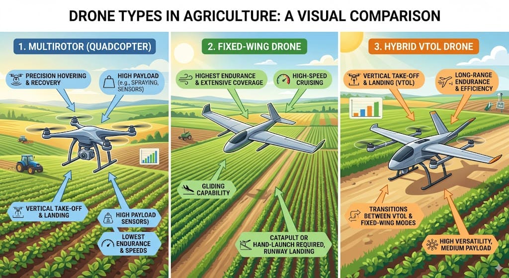
Fixed-Wing vs. Multirotor vs. Hybrid VTOL: Choosing the Right Platform
To understand why drones have become such a compelling asset in modern agriculture, we must first examine what makes them technically capable. Unmanned aerial vehicles for farming are not simply flying cameras; rather, they are sophisticated platforms equipped with an array of sensors, processors, and communication tools that enable them to collect, transmit, and interpret real-time data about crops, soil, and environmental conditions.
At the heart of any serious agricultural UAV is its sensor payload. Specifically, drone sensors in smart farming typically include RGB cameras for standard visual imaging, thermal sensors for detecting water stress and heat anomalies, LiDAR units for generating precise 3D maps of terrain and canopy structure, and, perhaps most critically, multispectral and hyperspectral imaging systems. Together, these sensors capture light across wavelengths invisible to the human eye, thereby allowing farmers and agronomists to detect problems that would otherwise remain hidden until significant damage occurs.
Fixed-wing drones offer extended flight range and are well-suited for covering large, flat farmland efficiently. In contrast, multirotor drones, the more familiar quadcopter and hexacopter variants, provide greater hovering stability and vertical precision, making them ideal for tasks like targeted spraying or close-range crop inspection. Hybrid VTOL (Vertical Take-Off and Landing) drones are increasingly popular because they combine the range of fixed-wing platforms with the flexibility of multirotors. The choice of platform is a critical first step in any precision agriculture UAV application, as it directly influences what tasks the system can perform, how much area it can cover per flight, and what payload it can carry.
Current Limitations: Payload Capacity and Flight Autonomy
Drone payload and flight autonomy issues remain an ongoing engineering challenge. For instance, many commercial agricultural drones have limited battery life, typically 20 to 45 minutes per charge, and payload restrictions that can constrain their spraying capacity. Nevertheless, rapid improvements in battery technology, hydrogen fuel cells, and swarm drone coordination are beginning to address these limitations in meaningful ways.
Comparison of Agricultural Drone Platforms
| Platform Type | Typical Flight Time | Payload Capacity | Best Suited For | Key Advantages | Limitations |
|---|---|---|---|---|---|
| Multirotor (Quadcopter/Hexacopter) | 20–35 minutes | 1–10 kg (spraying models up to 40L) | Targeted spraying, close-range inspection, small to medium fields | High stability, vertical takeoff/landing, precise hovering | Shorter flight time, limited area coverage per flight |
| Fixed-Wing | 45–90 minutes | 1–3 kg | Large-scale mapping, broad acre crops (corn, wheat, soy) | Long endurance, covers large areas efficiently | Requires launch/landing space, cannot hover |
| Hybrid VTOL | 35–70 minutes | 2–5 kg | Versatile operations requiring both range and precision | Combines fixed-wing range with multirotor flexibility | Higher cost, more complex systems |
Crop Monitoring: A Primary Application of Drones in Agriculture
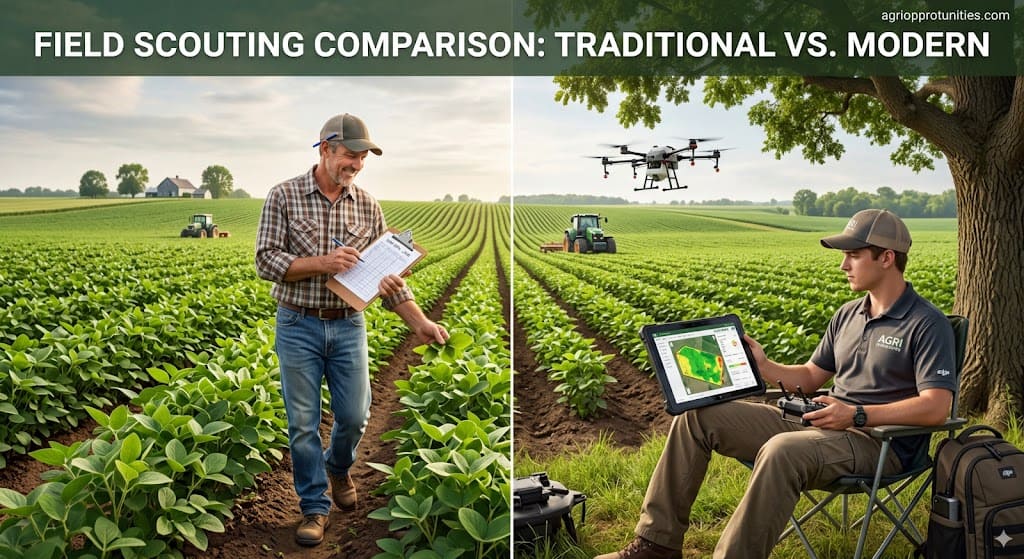
1. From Ground Scouting to Aerial Intelligence
One of the most transformative applications of precision agriculture UAV applications is crop monitoring. Traditionally, monitoring relied on ground-level scouting, a labor-intensive process that could only sample small portions of a field at any given time. On the other hand, satellite imagery offered a broader view but was constrained by cloud cover, revisit frequency, and resolution limitations. As a result, drones fill the gap between these two extremes, delivering unmatched precision, flexibility, and timeliness.
Crop health monitoring with drones has become one of the most widely adopted UAV use cases globally. When a drone equipped with multispectral sensors flies systematic grid patterns over a field, it captures data that processing converts into NDVI (Normalized Difference Vegetation Index) maps, color-coded visualizations that show the relative health and biomass density of every square meter of a crop. Stressed, diseased, or nutrient-deficient areas appear distinctly, enabling farmers to intervene early before problems cascade into widespread losses.
2. Thermal, Multispectral, and LiDAR Applications
Aerial imaging for crop stress detection goes beyond NDVI. For instance, thermal imaging drones can identify areas where crops are experiencing water stress by mapping surface temperature differentials, cooler areas with adequate water versus warmer, drought-stressed patches. With this level of insight, irrigation can be applied exactly where it is needed, eliminating the waste and inefficiency of blanket irrigation systems. Similarly, pathogen infestations, pest damage, and fungal infections produce unique spectral signatures that can be detected from the air well before they are visible to the naked eye from the ground.
Farmers use drone data to analyze soil and plan before planting. Specifically, UAVs map soil variability, drainage patterns, and elevation gradients, letting farmers choose optimal planting locations, apply soil amendments efficiently, and design effective drainage. By integrating this data into farm management software, farmers can manage each field site-specifically — which is the core of precision farming.
3. Multispectral Imaging for Crop Health
Farmers should prioritize multispectral drone analysis because UAVs give them one of agriculture’s most valuable technical tools. Standard RGB cameras capture only red, green, and blue light visible to humans, but multispectral cameras measure five or more spectral bands, including near-infrared (NIR) and red-edge bands, which reveal vegetation health and chlorophyll content.
When crops are under stress, whether from disease, drought, excessive salinity, or nutrient deficiency, their ability to absorb and reflect light at specific wavelengths changes before visible symptoms appear. A multispectral drone can detect these changes early, giving farmers a critical window of opportunity to apply corrective measures. As a result, the resulting maps are not just visually informative; they can be directly exported as variable rate application (VRA) prescription maps, guiding machinery to apply fertilizers, pesticides, or water only where the data indicates it is needed. In turn, this precision dramatically reduces input waste and increases the efficiency of every dollar spent on crop inputs.
Among the best UAV sensors for agricultural monitoring are platforms like the MicaSense RedEdge series, the Parrot Sequoia, and DJI’s Zenmuse P1 and Zenmuse L1, all of which are tools that are increasingly accessible and capable of delivering actionable agronomic intelligence at scale.
Agricultural Drone Sensors and Their Applications
| Sensor Type | Spectral Bands Captured | Key Agricultural Applications | Output Products |
|---|---|---|---|
| RGB Camera | Red, Green, Blue (visible) | Field mapping, visual inspection, crop counting, weed identification | Orthomosaic maps, 3D models, visual imagery |
| Multispectral Sensor | 5+ bands including NIR, Red-edge | Crop health analysis, NDVI mapping, nutrient deficiency detection, early disease identification | Vegetation indices (NDVI, NDRE), prescription maps |
| Thermal Sensor | Long-wave infrared (thermal) | Irrigation management, water stress detection, crop temperature monitoring | Temperature heat maps, stress zone identification |
| LiDAR | Laser pulses (3D point cloud) | Terrain mapping, canopy structure analysis, biomass estimation, drainage planning | 3D elevation models, canopy height maps, volumetric measurements |
UAV Precision Spraying: A Game Changer in the Field
1. UAV Spraying vs Conventional Techniques
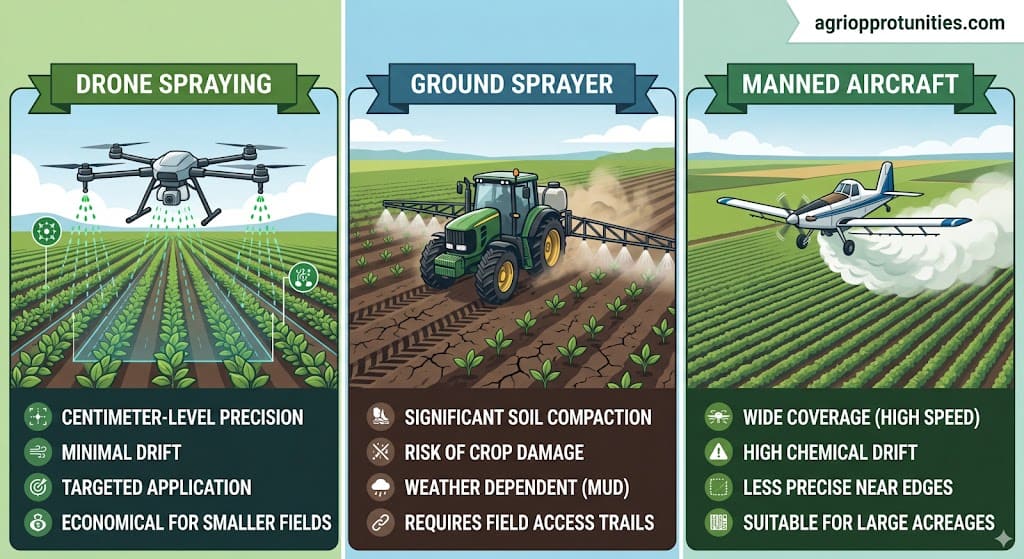
Perhaps the most visually dramatic and practically significant use case for agricultural drone technology is aerial spraying. UAV precision spraying benefits are wide-ranging and impact everything from input costs to environmental outcomes. Traditional ground-based sprayers, while effective, are heavy, compact soil, and can physically damage crops during application. Conventional aerial spraying via manned aircraft, while efficient at scale, lacks precision and often results in significant chemical drift.
Drone-based spraying changes this equation entirely. Modern agricultural spraying drones, like the DJI Agras series, which has become a global benchmark, can carry liquid payloads of 10 to 40 liters and cover several acres per hour with pinpoint accuracy. Using real-time terrain-following sensors and GPS-guided flight paths, these drones maintain a consistent spray altitude above the crop canopy, ensuring uniform droplet distribution even over uneven terrain. The downwash from the rotors also helps to push the spray into the canopy rather than allowing it to drift, a significant advantage over conventional aerial methods.
2. Yield Impacts and Chemical Reduction Benefits
The question of how do drones improve crop yields in precision farming is answered, in part, through spraying efficiency. Studies and field data from countries including China, Japan, India, and the United States consistently show that drone spraying reduces pesticide use by 20 to 40 percent compared to traditional methods, while achieving equivalent or superior coverage. This reduction in chemical input directly translates to lower costs, reduced chemical residues on produce, and decreased environmental contamination in surrounding ecosystems.
The benefits of drones in sustainable agriculture extend well beyond spraying efficiency. Specifically, because drones enable site-specific management, applying inputs only where and when they are needed, they help reduce the overall chemical footprint of farming operations. In turn, this supports soil health, reduces runoff into waterways, and contributes to more environmentally responsible food production systems. Consequently, for farms pursuing organic certification or sustainability-based market premiums, drone-enabled precision management is an increasingly important competitive advantage.
This focus on ecological balance aligns closely with the principles of regenerative agriculture , where the goal is to actively improve farm ecosystems through practices like minimal tillage, cover cropping, and holistic land management.
Table 3: Spraying Method Comparison: Drone vs. Conventional Approaches
| Parameter | Drone-Based Spraying | Ground-Based Sprayers | Manned Aerial Spraying |
|---|---|---|---|
| Precision | Centimeter-level (RTK GPS) | Meter-level | Low to moderate |
| Chemical Drift | Minimal (downwash reduces drift) | Moderate | High (significant drift risk) |
| Soil Impact | None (no soil contact) | Soil compaction from heavy equipment | None (no soil contact) |
| Crop Damage | None (overhead application) | Physical damage to plants possible | Minimal |
| Terrain Adaptability | Excellent (can operate on slopes, wet fields) | Limited (difficult in wet or uneven terrain) | Good (can cover large areas quickly) |
| Labor Requirement | Low (1–2 operators) | Moderate to high | Moderate (pilot + ground crew) |
| Typical Application Rate | 10–40 liters per hectare | 50–200 liters per hectare | 20–50 liters per hectare |
| Input Reduction vs. Conventional | 20–40% less pesticide/fertilizer | Baseline | 5–15% less (if properly managed) |
Future Directions: How AI and IoT Enhance Drones in Agriculture
1. AI and Machine Learning: From Data Collection to Autonomous Decision-Making
The true power of drones in precision agriculture comes not from the hardware alone. Instead, intelligent systems that process, interpret, and act on the data collected by drones unlock their full potential. Among the most significant developments in recent years, integrating AI and machine learning has transformed drones from passive data collectors into active decision-support systems.
For example, machine learning models trained on thousands of labeled crop images can now identify specific disease types, pest species, weed populations, and nutritional deficiencies from drone imagery with accuracy rates that rival or surpass expert agronomists. Platforms like Taranis, Cropwise (formerly Cropio), and John Deere’s Operations Center are already incorporating AI-driven drone data analytics into their precision agriculture ecosystems. As training datasets grow and algorithms mature, these systems will become increasingly capable of providing hyper-local, crop-specific recommendations in near real time.
2. IoT Connectivity and Real-Time Farm Automation
IoT connected drones for crop analytics represent another frontier of integration. When drones are part of a broader IoT agricultural ecosystem, sharing data with soil sensors, weather stations, irrigation controllers, and yield monitors, the resulting insights are far more comprehensive and actionable than any single data source could provide. Imagine a system where a drone detects early signs of moisture stress in a specific field zone, automatically cross-references this with nearby soil moisture sensor readings and local evapotranspiration data, and then triggers a targeted irrigation event, all without human intervention. This kind of automated, data-driven farm management is not science fiction; it is being piloted on progressive farms around the world today.
3. GIS Integration and Spatial Data Management
Farmers gain additional value by integrating drones with Geographic Information System (GIS) tools. Specifically, GIS allows them to overlay drone-collected spatial data with historical yield maps, soil survey data, topographic information, and land ownership records. The result is a dynamic, multi-layered understanding of a farm’s productive capacity and constraints, a tool that proves invaluable for both day-to-day management decisions and long-term strategic planning.
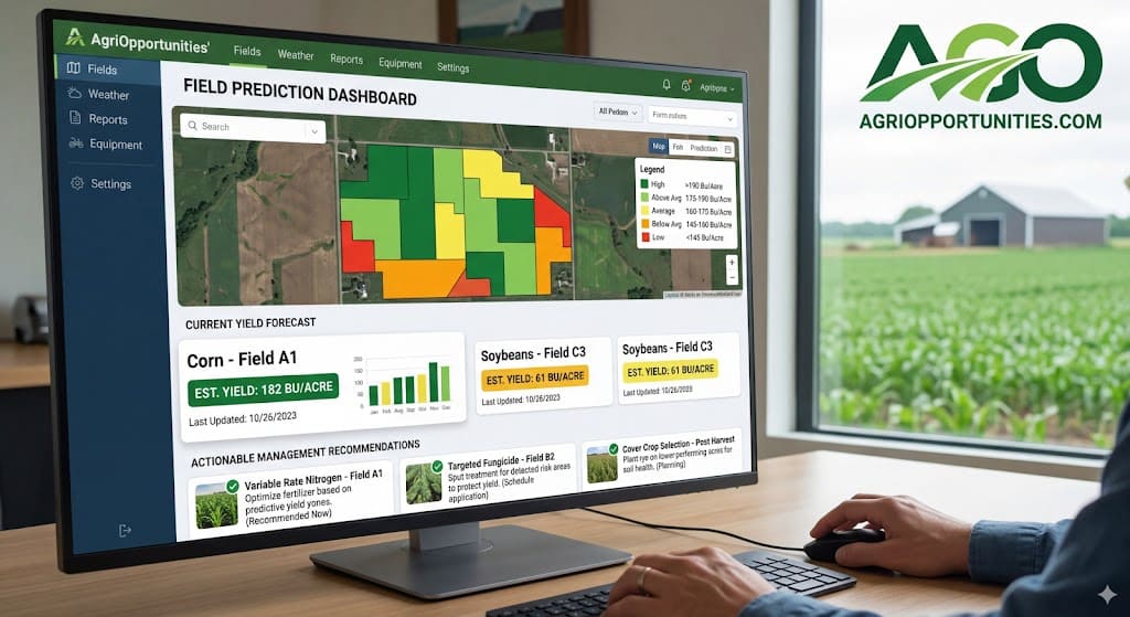
4. Predictive Analytics for Yield Forecasting
Drone data analytics for yield prediction is an area attracting significant investment from agri-tech companies and research institutions alike. By correlating drone-derived crop health indices, canopy density measurements, and flowering density estimates with historical yield data, predictive models can generate surprisingly accurate pre-harvest yield forecasts weeks or even months before harvest. For example, for farmers, these forecasts support better marketing and logistics decisions. For commodities traders and food companies, they offer a valuable window into supply chain expectations. Similarly, for lenders and insurers, they provide objective, data-driven assessments of crop performance, reducing risk and potentially lowering the cost of agricultural finance.
These integrated systems are part of a larger movement toward autonomous, data-driven operations. The evolution of such technologies is explored in detail within the field of agricultural robotics , which covers autonomous tractors, robotic harvesters, and AI-powered weed control.
Cost, Adoption, and Challenges for Agricultural Drones
Agricultural Drone Cost and ROI Analysis
No discussion of technology is complete without an honest look at cost. Naturally, agricultural drone cost and ROI analysis remains a key concern for every farm manager and agri-investor considering this space. Fortunately, the good news is that over the past decade, the cost of agricultural drone hardware has fallen dramatically. For instance, entry-level multispectral mapping drones can now be purchased for $5,000 to $15,000, while more advanced spraying platforms range from $15,000 to $40,000 or more. However, professional-grade sensor suites, software subscriptions, and training add to the total cost of ownership.
However, cost must be evaluated against the tangible returns. Fortunately, research from multiple global agricultural institutions consistently shows that drone-enabled precision farming can reduce input costs, including fertilizer, pesticide, and water, by 15 to 30 percent while improving yields by 5 to 20 percent, depending on the crop, region, and management practices in place. For a mid-sized grain operation, these improvements can translate into tens of thousands of dollars in annual savings and additional revenue. As a result, the payback period for a well-managed agricultural drone investment typically ranges from one to three growing seasons, a compelling ROI by any standard.
For smallholder farmers in developing countries, purchasing agricultural drones individually may not be economically feasible. However, the emergence of drone-as-a-service (DaaS) business models is expanding access to this technology. Consequently, cooperatives, agri-service companies, and government programs increasingly provide drones to smallholder farms, pooling equipment across multiple farms to spread fixed costs and give farmers operating on just a few acres access to professional drone services.
Cost and Adoption Barriers for Agricultural Drones
Despite the compelling economic case, farmers in lower-income agricultural regions still face significant cost and adoption barriers for agricultural drones. In addition to the initial hardware investment, they must cover ongoing expenses for software licensing, data storage, maintenance, repairs, and operator training. Moreover, many farmers, particularly older generations with extensive practical experience but limited exposure to technology, find the learning curve steep and the return on their time investment uncertain.
Precision agriculture technology challenges also include data management complexity. A single drone flight over a large farm can generate gigabytes of raw imagery that must be processed, stitched into orthomosaic maps, analyzed, and translated into actionable recommendations. Without the right software tools and adequately trained personnel, this data can quickly become an overwhelming liability rather than a valuable asset. Addressing this challenge requires investment not just in technology but in education, extension services, and user-friendly software interfaces that make precision agriculture accessible to farmers with varying levels of technical sophistication.
UAV Regulations and Farm Deployment Barriers
Regulations for farm UAV deployment vary significantly by country and region, creating an uneven playing field for adoption. In the United States, the FAA enforces Part 107 rules for commercial drone operations, requiring licensed pilots and restricting flights over people, at night without a waiver, and beyond visual line of sight (BVLOS), which significantly limits large-scale agricultural deployment. Meanwhile, the European Union’s EASA regulations create a tiered framework based on drone weight and operational risk. Across Asia, Africa, and Latin America, many countries are still developing their regulatory frameworks, presenting both uncertainty and opportunity for drone adoption.
Agricultural drone operators must stay current with local rules, maintain proper certification, and often work directly with regulatory authorities to secure special permissions for advanced operations. At the same time, industry advocacy organizations and drone manufacturers actively collaborate with governments to develop regulations that balance safety concerns with the practical needs of agricultural applications, and they continue to make gradual progress.
Case Studies: UAV Yield Optimization Strategies
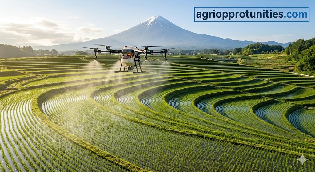
Real-world results are the most persuasive argument for any technology, and the global experience with precision agriculture UAV applications is generating a growing library of compelling case studies. For instance, in Japan, which has used agricultural drones for rice spraying for over two decades, UAV adoption has contributed to significant reductions in chemical inputs while maintaining stable yields in a country where farm labor is chronically scarce. Similarly, in India, government-subsidized drone spraying programs have demonstrated cost savings of up to 30 percent on pesticide applications across rice, cotton, and wheat crops. In sub-Saharan Africa, NGO-supported drone mapping initiatives have helped smallholder farmers identify soil degradation hotspots and implement targeted soil conservation measures with measurable yield improvements.
In precision-driven agricultural markets such as the United States, Australia, and the Netherlands, progressive operations increasingly integrate drone data analytics for yield prediction with farm management platforms. Growers who use these systems report that they improve input efficiency, reduce crop losses from undetected disease and pest pressure, and enable more confident, data-driven decision-making across all aspects of farm management. The cumulative evidence is clear: when implemented thoughtfully, agricultural drones deliver measurable, meaningful value across a wide range of farming systems and geographies.
Looking Forward: The Future of Drones in Precision Agriculture
The trajectory of drones in agriculture points toward a future innovations in agricultural UAVs is pointing toward a future in which drone-based management is not an optional add-on but an integral component of standard agricultural practice. Advances in battery energy density, solar charging integration, and hydrogen fuel cell technology are extending flight times and operational ranges. Swarm drone technology, coordinating multiple UAVs simultaneously across a single large field, is moving from experimental to practical. Edge computing capabilities are allowing more data processing to happen on-board the drone itself, reducing the time between data collection and actionable insight.
The convergence of AI and machine learning for agricultural drones, high-resolution multispectral sensing, and seamlessly integrated IoT ecosystems is enabling truly autonomous, self-optimizing farm management systems. In this emerging paradigm, drones do more than collect data for humans to interpret, they actively participate in a continuous feedback loop of observation, analysis, and adaptive management, operating at a speed and scale that no human team can match.
For farmers, investors, students, and policymakers shaping the future of agriculture, understanding and embracing drones in precision agriculture is essential. Farms that thrive in the coming decades will integrate the intelligence of these aerial systems with the irreplaceable wisdom of experienced, land-connected farming communities. This synthesis, using technology to enhance human knowledge rather than replace it, offers the most promising path forward for global food security, environmental sustainability, and agricultural prosperity.
Frequently Asked Questions
1. What are drones and how are they used in agriculture?
Drones, formally known as unmanned aerial vehicles (UAVs), operate remotely or autonomously and carry sensors, cameras, or other payloads. Farmers use them for a wide range of tasks, including crop mapping, health monitoring, aerial spraying, soil analysis, irrigation management, and yield forecasting. They give farmers a bird’s-eye view of their operations along with detailed, actionable data.
2. How do drones improve agricultural productivity?
Drones improve productivity by enabling faster, more accurate identification of crop problems, including disease, pest damage, water stress, and nutrient deficiencies, allowing for timely, targeted interventions. They also optimize input application through precision spraying, reduce scouting labor costs, and provide data that supports better overall farm management decisions. The combined effect is higher yields, lower input costs, and more efficient use of resources.
3. Can drones reduce the use of pesticides and fertilizers?
Yes, one of the most well-documented benefits of drone-enabled precision agriculture lies in its ability to identify exactly which areas of a field require treatment. By doing so, drones allow farmers to apply pesticides and fertilizers at variable rates, eliminating the waste that comes from blanket application across entire fields. Studies from multiple countries consistently show that farmers reduce chemical usage by 20 to 40 percent without compromising crop protection efficacy.
4. Are agricultural drones cost-effective?
For most medium- to large-scale farming operations, agricultural drones deliver a strong return on investment, with farmers typically recouping costs within one to three seasons. Smaller farms can access drone technology cost-effectively through drone-as-a-service models instead of purchasing hardware outright. As hardware costs decline and software capabilities improve, farmers across all farm sizes and types increasingly see a compelling economic case for adopting drones.
5. What types of agricultural tasks can drones handle?
Modern agricultural drones can handle an impressive range of tasks, including field mapping and surveying, multispectral crop health analysis, thermal imaging for irrigation management, targeted pesticide and fertilizer spraying, seed and beneficial insect dispersal, livestock monitoring, fence and infrastructure inspection, and pre-harvest yield estimation. The range of capabilities continues to expand as sensor and software technology advances.
6. What technologies do agricultural drones use?
Agricultural drones combine a wide array of technologies, including GPS and GNSS navigation systems, multispectral and hyperspectral imaging sensors, thermal cameras, LiDAR units, real-time kinematic (RTK) positioning for centimeter-level accuracy, AI-powered image analysis software, GIS mapping platforms, IoT data integration protocols, and cloud-based analytics systems. Building on these capabilities, the most advanced platforms use machine learning algorithms to automatically detect and classify crop health issues from aerial imagery.
7. Are there challenges to adopting drones in farming?
Yes, however, challenges remain. Among them are the upfront cost of hardware and software, the learning curve for data interpretation, limited battery life and payload capacity on current platforms, evolving and sometimes restrictive regulatory frameworks, connectivity limitations in remote rural areas, and the need for ongoing maintenance and operator training. Despite these hurdles, the challenges are real but manageable, and the industry is actively developing solutions to address each of them.
8. How often should a farm use drones for monitoring?
The optimal frequency depends on the crop type, growth stage, and specific management objectives. For high-value crops like vegetables, fruits, and specialty crops, weekly or even twice-weekly flights during critical growth periods may be justified. For field crops like corn, soybeans, or wheat, bi-weekly or monthly monitoring is typically sufficient, with additional flights triggered by specific events such as unusual weather, disease alerts, or observed field problems. Many precision agriculture consultants recommend establishing a baseline monitoring schedule at the beginning of each season and adjusting based on what the data reveals.